 English


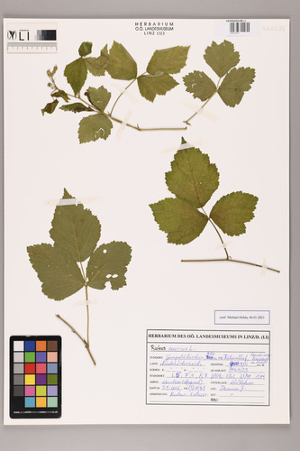
Viridiplantae Spermatophyta Dicotyledoneae Rosaceae Rubus
Rubus caesius L.
Occurrence ID: 102167729
status (botany): k
det.: Michael Hohla, Obernberg am Inn
date: 4.1.2021 (dd.mm.yyyy)
federal state: Niederösterreich
country: Österreich
geographic coordinates: 48° 4' 30" N, 16° 17' 30" O
accuracy (meters): 4200m
sea level: 350m
MTB (Messtischblatt): 7963/2
Barcode: 04010517
date: 3.9.2005 (dd.mm.yyyy)
locality: Laubwald(rand)
collection code: (7) 1091
status (botany): k
det.: Michael Hohla, Obernberg am Inn
date: 4.1.2021 (dd.mm.yyyy)
location
location: Gumpoldskirchen, 450 m NE Richardhof, Wanderwegkreuzung im Waldfederal state: Niederösterreich
country: Österreich
geographic coordinates: 48° 4' 30" N, 16° 17' 30" O
accuracy (meters): 4200m
sea level: 350m
MTB (Messtischblatt): 7963/2
Barcode: 04010517
Collector
leg.: Josef Danner, Sandldate: 3.9.2005 (dd.mm.yyyy)
Collection
coll.: des OÖ. Landesmuseums (LI)notes
substratum: Lößlehmlocality: Laubwald(rand)
collection code: (7) 1091